
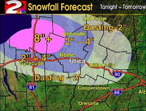
WKTV's weather map (as of last evening) and Extended Forecast:
"Lake effect will begin to diminish as we head into your Monday. High pressure should give us a quiet day, at least for one day. A cold front moves through on Tuesday, and we'll be dealing with very cold temperatures by Tuesday morning, along with more lake effect. A storm system moves near us on Wednesday, and it could give us some light snow. More cold air and lake effect to follow behind this system. We'll gradually warm into the 20s by next weekend."
I've spent the last hour or more going to various websites, including the Watertown Daily News and Channel 7 in Watertown, looking for some dramatic snowstorm photographs to show you, but I couldn't find any!

A few people have asked if Dick and I would be driving up towards Tugg Hill, today, to take pictures. Well - probably not, although the idea is appealing! I don't think that they need any more gawkers any more than we need to be driving in the blizzard conditions that still persist, there.
We'll probably go back to Millers Mills to get a chunk of Ice Harvest Excitement and a cup of hot chocolate! Perhaps we'll see you there!